INTRODUCTION
The Japan and Okhotsk Seas are divided by shallow area located between Sakhalin Island from the north and Hokkaido Island from the south, and 142.0 E from the west and 143.5 E-from the east (Fig.1).
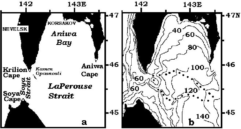
Bottom troughs are indicated by dots. Depth — in meters.
This area, despite of special bottom topography and special oceanographic conditions, has no name. But the narrowness between Krilion Cape and Soya Cape has even two names: in Russia — Laperuza (LaPerouse) Strait, and in Japan — Soya Strait. In this paper the waters of area between the Sakhalin and Hokkaido islands, 142 E and 143.4 E are considered in a whole, therefore hereinafter all this area we'll name (for convenience of the description) as LaPerouse Strait and its western narrowness as Soya Strait.
Water structure and currents in area between Sakhalin and Hokkaido were studied by M. Aota (1970; 1975; 1984; 1987), V.D. Budaeva (1975; 1980) and T. Takizawa (1982), but main attention was given to Soya Current. Through LaPerouse Strait warm subtropical water penetrates (as Soya Warm Current) into the Okhotsk Sea. Results of not numerous measurements of currents (May-June 1933) in the strait indicate that subtropical water in summer enters into Soya Strait almost on all its width (with the exception of its northern part). After Soya Strait the width of this flow sharply decreases and further warm and salty water exists only in a narrow strip along northern coast of Hokkaido.
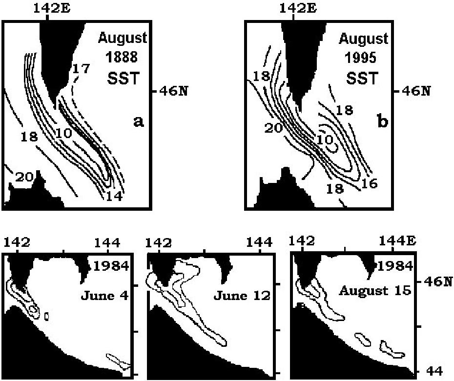
But main feature of water structure of waters of this area in a summer is a belt of cold water from Cape Krilion to southeast part of this strait (Fig. 2).
It is usually considered (Tanaka et al., 1996) that cold water inside the belt is formed OUTSIDE of the strait — at south-western coast of Sakhalin as the upwelling of subsurface (deep) waters. And is usually believed that cold water is transported FROM THERE into the LaPerouse Strait by so-called “West Sakhalin Current.” I. Zhabin (Zhabin et al., 1992) wrote: “cold waters through LaPerouse Strait penetrate in the Okhotsk Sea.” We have doubted if the cold water in belt are brought in here from the outside (the Japan Sea).
THE DATA
In this paper the data of 9 oceanographic expeditions carried out by the Sakhalin Hydrometeorological Administration in April-December of 1962 , April-July of 1963 and — by Far Eastern Regional Hydrometeorological Research Institute in September of 1991 are used. Measurements of wind and air temperature (1962-1991) at coastal Sakhalin stations and data of ice surveys in the strait in 1945 1959, 1961 were also involved. All of Russian oceanographic measurements in the strait (in total 272 oceanographic stations) were executed on 5 meridional sections: 142 E, 142.4 E, 142.9 E, 143.4 E and 46 N (fig. 4a). The western of sections (at 142 E) was situated to the west of Kamen Opasnosti Rock and another one (on 142.4 E) was located to the east of it. Thus, the most interesting part of the strait never in was investigated in details.
BOTTOM TOPOGRAPHY OF LAPEROUSE STRAIT
One of peculiar features of bottom relief of LaPerouse Strait is a small island or rock, named KAMEN OPASNOSTI (Rock of Danger) that divides Soya Strait in two unequal parts. It is located (45.8 N, 142.2 E) in a 8 miles to the southeast from Cape Krilion. The rock has a pretty small size (150 x 50m), however an extensive stony area of about 3 miles length is located around the rock (fig. 1). Shallow area between Krilion Cape and Kamen Opasnosti Rock and to the east of them, creates conditions for vertical mixing and homogeneous distribution of the oceanographic characteristics in the area southeast from Krilion Cape.
The depth in LaPerouse Strait is less than 200 m and, in general, decreases from east to the west. As well in 2 underwater troughs (fig. 1b) the depth decreases (on 100 m), from east on west. By these troughs the cold bottom water rises to the surface (Makarov, 1894). Deep-water pass (deeper than 60 m) at the center of Soya Strait allows to transfer the bottom water in the opposite direction.
Distribution of sediments at the bottom of LaPerouse Strait (Dyakova-Savelieva and Djakonov, 1954) gives the indirect description of currents in a strait. So, in the area between Cape Krilion and Kamen Opasnosti Rock and to the southeast from it (and the same — near Aniwa Cape) is located the zone of washed up sediments, that indirectly testifies to existence of strong current between Cape Krilion and Kamen Opasnosti Rock. And, on the contrary, in the most part of a strait the silt prevails, that testify to absence of a strong flows.
AIR TEMPERATURE, WIND AND TIDES
Annual mean air temperature in area of Cape Krilion (4 C°) is lower, than at located to the north of it Nevelsk (5 C°), Korsakov (3 C°) and Moneron island (4.5 C°). It is possible to explain this not only by an influence of warm Tsushima Current in Tartar Strait (Moneron and Nevelsk) and mainly — by an existence of cold waters in area of Cape Krilion. In winter (November–March) a parity between stations is opposite.
Winds of western and northwestern directions prevail both in a summer and in a winter in area of Krilion Cape and east of it (west of Cape Krilion the wind is opposite). At Moneron Island there is northeastward wind. At southwestern coast of the Sakhalin the winds directed to the south and southeast prevail. Therefore such winds can not cause an upwelling of subsurface water southwest of the Sakhalin, but they can cause an upwelling to a southeast off Cape Krilion.
Tides and tidal currents play an important role in distribution of oceanographic characteristics in LaPerouse Strait. Averaged sea level of the Japan Sea is about 20 cm higher than sea level of the Okhotsk Sea. So the mean flow of the surface water should be directed out of the Japan Sea through LaPerouse Strait into the Okhotsk Sea.
Actual currents between Kriljon Cape and Kamen Opasnosti Rock differ from the mean currents essentially. This is caused by daily changes of sea level of the Japan Sea (the sea level in Krilion changes within day on 120 cm) and strong tidal currents. The largest speed of tidal currents is observed in the narrowness between Krilion Cape and Kamen Opasnosti where it exceeds 400 cm/c (Veselova, 1963). By means of such tidal currents cold water from LaPerouse Strait penetrates to southwest coast of Sakhalin (but usually not so far).
Cold and low saline water exists in LaPerouse Strait within all year below than 20 m. It is updated each winter when in LaPerouse Strait an ice appears.
SEA ICE
Let’s consider typical features of sea ice distribution on an example of winter of 1945 (when detailed information on ice cover were collected by the USSR Hydrometeorological Service) — fig. 3. Sea ice in LaPerouse Strait occurs for the first time in the beginning of January, when the most part of Tartar Strait is already covered with ice.
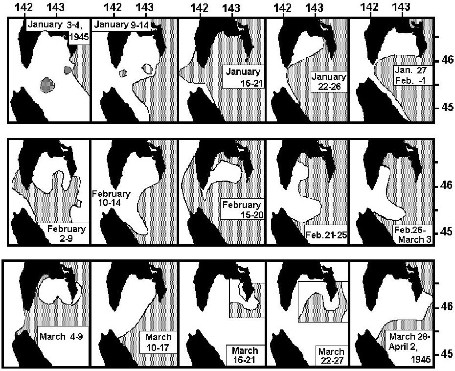
Ice is formed in Aniwa Bay during a whole winter and during a whole winter cold water is formed there too. In the beginning the ice, formed in Aniwa Bay, is taken out from a coast by offshore winds to the south and thaws there. Therefore ice cover in LaPerouse Strait becomes significant only with an appearence here of ice from the Okhotsk Sea. After it in Aniwa Bay coastal polyniya appeares (January 22; February 2; February 15; March 4).
By January 20 the ice completely covers the Strait and exists here up to middle of April. Since January and till April the ice conditions are changed many times, but ice drift is mainly directed to the Japan Sea. Sometimes pressure of ice from the Okhotsk Sea weakens so, that along Hokkaido and along Sakhalin the strips of clean waters appear (January 27). And sometimes pressure of ice grows so, that the ice penetrates in the Japan Sea (January 15; February 15).
The maximal distribution of ice in LaPerouse Strait occurs on 1 month later, than in Tartar Strait. The clearing up from ice of LaPerouse Strait occurs later too. In a winter main direction of a flow of subtropical water changes. In the beginning of winter the warm water passes into LaPerouse Strait mainly; and Tartar Strait quickly becomes covered by ice. But, when the ice of the Okhotsk Sea closes LaPerouse Strait, all warm water penetrates into Tartar Strait and the fast clearing up of the strait occurs. Hence, ice cover in Tartar Strait is connected with an ice cover in LaPerouse Strait: when ice cover of Tartar Strait is maximal, ice cover of LaPerouse Strait is minimal and on the contrary.
When LaPerouse Strait is closed by ice a warm subtropical water cannot to penetrate into LaPerouse Strait. Only sometimes (when ice pressure from the Okhotsk Sea weakens) warm water can in small volumes penetrate into the Strait near bottom. Vertical water structure of the strait in the beginning of winter and at the end of winter is different.
WATER MASSES IN LAPEROUSE STRAIT
Vertical water mass structure of LaPerouse Strait consists from three layers (Aota, 1970; Bobkov, 1995; Pischalnik, Arkhipkin, 1998): warm intermediate layer, cold subsurface layer and surface layer (the table 1).
The Table 1. Known water mass characteristics (water temperature (T, C°), salinity (S, ‰)) in LaPerouse Strait.
| Source | Warm Water Mass T S | Cold Water Mass T S | Surface Water Mass T S |
| Aota, 1970 | 3-17, 33.6-34.0 | -1.0-3.0, 32.5-33.2 | -1-14, 31.2-32.5 |
| Bobkov, 1995 | 12-18, 33.5-33.9 | -1.2-0.5, 33.0-33.2 | 8-15, 32.4-32.7 |
| Pischalnik, Arkhipkin,1998 | 2-11, 33.1-34.0 | -1.5-2.5, 32.6-33.6 | 2-18, 31.2-32.6 |
| Pischalnik,1998 | 2-20, 33.1-34.0 mean 5.8, 33.7 spring 9.0, 33.6 summer 6.8, 33.5 autumn | -1.5-2.0, 32.4-33.4 0.4, 33.0 spring 0.2, 33.0 summer 0.2, 32.8 autum> | 2-18, 31.2-33.0 6.7, 32.2 spring 11.4, 32.2 summer 7.6, 32.0 autumn |
However, the data of summer 1991 (Fig. 4) allow us to allocate not three, but four water masses (two different water masses may be identified in the surface layer):
- Surface Water Mass of low salinity;
- Surface Water Mass of high salinity;
- Cold Subsurface Water Mass;
- Intermediate Warm Water Mass of high salinity.
Of course, number of water masses is different in different seasons (two water masses are typical for winter and four — for summer) and at different sections (two water masses are typical for section along 142 E, and four water masses — for 143.4 E). But, in general, four water masses are met in LaPerouse Strait more often than three ones.
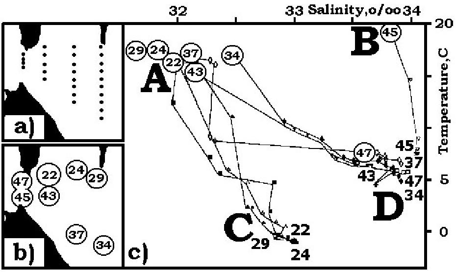
Typical stations (September 1991) can be divided into 4 groups, at which water structure is different: A+D (stations 34, 37, 43); A+C (stations 22, 24, 29); B+D (station 45); D (station 47). It is necessary to note that there is not combination of B+C (salty surface water and cold subsurface water). It means that core of salty water is situated not at the surface, but near bottom only.
The typical characteristics of water masses are presented in the table 2.
The table 2. Temperature(C), salinity(o/oo), density and dissolved oxygen (ml/l) in core of basic water masses in LaPerouse Strait in summer of 1991.
| Section/Water Mass | A-Surface Fresh (0-10m) | B-Surface Salty (0-10m) | C-Subsurface Cold (30-100m) | D-Intermediate Warm (20-100m) |
| 142.0 E | - | 19,33.8, 24.2,5.3 | - | 8, 34.1,26.6, 6.4 |
| 142.4 E | 17,32.0, 23.3, 5.2 | 16,33.8, 24.9,5.6 | -0.7,32.9, 26.5,5.1 | 8, 34.0,26.5, 6.4 |
| 142.9 E | 17,31.8, 23.1, 5.1 | 15,32.7, 24.2,6.0 | -1.0,32.8, 26.4,5.3 | 7, 33.6,26.4, 5.3 |
| 143.4 E | 17,32.0, 23.3, 5.9 | 14,33.2, 24.8,5.9 | -1.1,32.9, 26.5,6.1 | 8, 33.9,26.4, 6.3 |
Surface Salty Water differs from Surface Fresh Water by up to 2‰ salinity. Surface Fresh Water occupies almost all LaPerouse Strait, except for a narrow strip along Hokkaido. Typical feature of this water is low salinity (less than 33.0‰). Surface Salty Water occupies a narrow strip along Hokkaido. Typical feature of this Water is high salinity (more than 33.8‰). Water temperature of surface water both from the Japan Sea (salty), and from the Okhotsk Sea (low saline) in summer is almost identical (15-17 C°).
A sharp thermal front divides these water masses. Waters to the south from front have temperature more than 4 C° in April and 8 C° in May, while to the north from frnt the temperature is less than 2 C° in April and less than 5 C° in May. The warm and salty surface water disappeares in November (Aota et al., 1970) or in August (Pischalnik, Arkhipkin, 1998). But even in December (1962) we have found this water (warm and salty) on the surface close to Hokkaido.
Intermediate Water Mass of high salinity (and high temperature) differs from surface salty water, first of all, in temperature. For example, in September 1991 the difference in temperature achieves 15 C°. On the 142 E section Intermediate Water Mass exists at all stations, but on other sections — only at southern stations. On a section at 142 E the core of high salinity was located near the bottom as in the winter (50m — December 1962) and in the Spring (60m-April 1962; May 1963), as in a summer (June 1963; September 1991). The greatest salinity on a section on 142 E was marked in September 1962 (10m-34.63‰). But usually the salinity in a core is a little bit below: in May 1962 — on 50m level — 34.31‰), in December 1962 — 34.23‰, in April 1963 — 34.27‰.
The position of highest salinity does not coincide with the position of highest temperature. Highest temperature in a summer is typical for a surface layer.
Subsurface Cold Water is situated in LaPerouse Strait below Surface Waters (as salty as fresh ones) and down to the bottom. Its typical feature is low temperature (but also and rather low salinity). The depth of a core of this water mass grows from east border of the strait (143.4 E) up to western (142 E) border. Water of lowest temperature and Water of lowest salinity don’t coincide with each other in space. For example, in May 1962 on 142.9 E temperature less 2 C° was below 20 m, but salinity less 32.5 — just above it).
The temperature of Subsurface Cold Water depends on a season. Just after winter (in April and May) water temperature in its core is close to temperature of freezing (-1.7 C° — -1.0 C°); In a summer (June, September) the area engaged in water with negative temperature decreases; and in December water of this layer already everywhere has positive temperature (but, nevertheless, below 2 C°).
We have named a subtropical (high salinity) water as “intermediate” and of subarctic (cold) water as “subsurface”, because in their collision (though, the border between them usually is almost vertical) subtropic water is situated below than subarctic water.
SPATIAL DISTRIBUTION OF TEMPERATURE AND SALINITY
In general, isotherms in LaPerouse Strait are situated along a line NW-SE (parallel to the northern coast of Hokkaido). The main feature of the surface temperature field is thermal front. Thermal front divides warm and cold waters. Front represents an output on the surface of basic thermocline. In case at the surface there is a belt of cold water, instead of one front of temperature two appear.
In this case the belt of cold water is situated between fronts (frontal lines). Gradient of water temperature achieves 3 C° on 10 miles. But even in case of absence of the belt at the surface the belt exists at levels below the surface. So, the belt of cold water is typical feature of oceanographic structure of LaPerouse Strait.
In June 1963 (fig. 5) belt was typical (lowest temperature in the belt was near Cape Krilion); in April 1962 the belt was unusual (lowest temperature was in the southeastern part of the Strait), but typical for another (subsurface) levels; in October 1958 situation was unusual: there were two belts (one — from Cape Krilion, another — from Aniwa Cape).
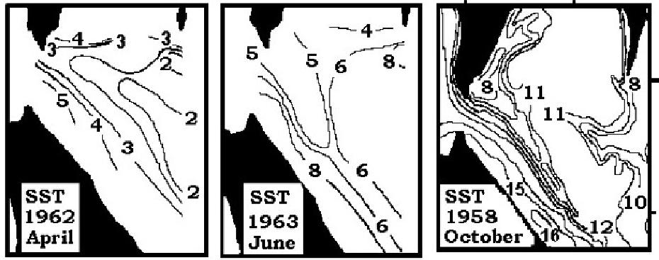
Scheme of October 4-10, 1958 is taken from paper of K. Furuya (1994).
In April (1962) the belt is directed to Cape Krilion. Temperature inside the belt rised from 1.8 C° (in southeastern part of the strait) to 2.8 C° (near Cape Krilion). Highest temperature at the surface there are as near Hokkaido (more than 5 C°) as in Aniwa Bay (more than 4 C°). In April 1963 the belt was absent at the surface. In Soya Strait water temperature rised from 2 C° (near Cape Krilion) to 7 C° (near Cape Soya).
In May (1962) the belt has very small size (just between Cape Krilion and Kamen Opasnosti Rock). Inside the belt lowest temperature was less than 3 C°. In May 1963 size of the belt at the surface was small also and lowest temperature was about the same (about 3 C°).
In June (1963) at the surface the belt was weak one. Lowest temperature inside the belt was less than 5 C°.
And in October (1958) in addition to belt from Cape Krilion (lowest temperature was less than 8 C°) there was a belt from Aniwa Cape (lowest temperature was the same). Both areas of cold water appears at the surface as the results of an upwelling of subsurface water. Direction of cold water distribution at the surface coincides with the direction of prevailing currents: directed to the southeast from Krilion Cape (according to Soya Current); and directed to the northwest from Cape Aniwa (according to East Sakhalin Current and LaPerouse Current).
Below the surface (fig. 6) distribution of cold water was usually the same in different surveys:
cold belt was directed from southeastern part of the Strait to Cape Krilion. Lowest temperature was in southeastern side of the belt usually. It means that cold water penetrate in area of Cape Krilion from southeastern part of the Strait.
Temperature of cold water in the belt decreased with growth of depth (core of Subsurface Cold Water is located near bottom). Water with negative temperature was situated just below 30m.
In all surveys (in spite of the belt at the surface is absent) the cold belt was revealed at levels below 20m. For example, in September 1991 lowest temperature (below 6 C°) was marked near Krilion Cape (at 20m) and below than 5 C° (at 30m).
Distribution of salinity has some features too: front of salinity coincides with thermal front and areas, for which the low values of water temperature are characteristic, differ also by low salinity — fig. 7.
Distribution of water temperature at main sections (142.4 E, 142.9 E, 143.4 E) for a summer (when the belt was revealed most frequently) — June 1963 and September 1991 — is presented on fig. 8. West of the entrance to the Strait (142 E) water temperature from April to December did not fall below 0.6 C°. The border of water masses on this section usually passes on distance of 8 miles from Cape Krilion-to the north of 45.8 N. Inside this narrow strip water with salinity less than 33‰ exists sometimes only.
Cold Subsurface Water was always presented at all sections. On the 142 E section (west of Cape Krilion) it was found out sometimes at the most northern station only). For example, in September 1991 Cold Water was not far than 3 miles from Cape Krilion. On the 142.4 E section (east of Kamen Opasnosti Rock) Subsurface Water was always found. On this section this Cold Water was located closer to the surface, than on other sections. On the third section (142.9 E) Cold Water is always located to the north of 45.3 N, and on 143.4 E section it occupies almost all the Strait. Core of this water and its top border rise from east on west according to change of a bottom relief, while the core of Warm Intermediate Water on all sections there is near the bottom.
For example, in April, 1963 the depth of the top border has risen from 35 m on 143.4 E up to 5m on 142 E. Water temperature of a layer in the a summer rises from 2 C° on 143.4 E up to 7 C° on 142 E, and salinity grows from 32.8‰ up to 33.5‰. As density of these waters in the summer is 26.4–26.5, and density of subtropical waters — 26.8–27.0, subtropical waters occupy the lower position.
DISCUSSION ON THE BELT OF COLD FRESH WATER
Belt of cold water near Cape Krilion was traced during most part of a year (April, May, June, August, September, October) and in different years (1888, 1958, 1962, 1963, 1991). The existence of the cold water belt (from Krilion Cape to the southeast) is usually explained (Tanaka et al.,1996; Zhabin et al., 1992) by an upwelling at west coast of the Sakhalin and by carry them into LaPerouse Strait by so-called (West) Sakhalin Current (Yurasov, Yarichin, 1991). But characteristics of deep surface and subsurface waters near the Sakhalin coast are distinct from characteristics of waters in the belt usually (with the exception of inflow of cold waters from LaPerouse Strait).
Water temperature in belt is 3-5 C° (in April–June) and 8-14 C° (in September–October) while salinity is within 32.0–32.6‰. Salinity of waters west of the Sakhalin is much more (salinity of surface water — 33.9–34.2‰ and salinity of deep water — about 34.0‰). Local formation of cold water at the surface is seen, for example, from temperature distribution in October 1958 (fig. 5) – lowest temperature is seen to the east of Cape Krilion. Therefore cold and fresh water in the belt is not brought from the Japan Sea — it is formed here — in LaPerouse Strait. On the contrary, cold water near south-western Sakhalin is brought from LaPerouse Strait. Prevailing at Cape Krilion offshore winds cause the upwelling of subsurface waters near it and characteristics of subsurface water here coincide with the characteristics of surface water in belt (fig. 9).
In common, the mechanism of formation of cold water belt is the next. Local cold waters are formed during winter ice formation in Aniwa Bay. Together with cold waters constantly penetrating from the Okhotsk Sea they form a layer of cold water existing during year.
Cold waters from the Okhotsk Sea move to Soya Strat as subsurface current. Because of special bottom topography of LaPerouse Strait the direction of this water transport is northwest. Upper border of this layer rise from the east to the west. Near Kamen Opasnosti Rock there are a long stony area. There in conditions of offshore winds and strong tidal currents active processes of upwelling and tidal mixing occur. Cold waters from area of Kamen Opasnosti are distributed along Soya current and their width decreases.
By strong tidal current typical for area between Kamen Opasnosti and Cape Krilion cold water penetrates into the Japan Sea and, under the influence of Koriolis force, moves to the north along coast of Sakhalin. Usually surface cold water is distributed not too far to the north from Cape Krilion, but sometimes under influence of storm winds this water reaches to Nevelsk. Direction of wind is very important for this fenomena. In case of winds of unusual directions this belt disappeares.
S.O.Makarov was usually considered (Veselova, 1963) to be the first person who described the belt of cold water (Makarov, 1894). We found that it is not correct. Actually the first person, who has wrote about this phenomena, was Russian hydrographer E. Maidel (1877; 1878; 1879). He has described numerous cases of current measurements from the Okhotsk Sea in the Japan Sea between Krilion Cape and Kamen Opasnosti. He has also noted, that salinity of waters penetrating into the northern part of the Strait is essentially lower than salinity of waters, penetrating in the Strait from the Japan Sea.
Another not well-known paper of Dr. Zuev (1887) has noted that the width of cold strip along the Sakhalin decreases to the north (from 8 miles at Krilion up to 4 miles on 46.8 N) and is connected with cold flow from LaPerouse Strait and tidal currents.
COLD KRILION CURRENT AND COLD WEST SAKHALIN CURRENT
Makarov's map of SST (fig. 2a) is identical to map (fig. 2b) of Tanaka et al. (1996), but their explanations of this phenomenon are opposite ones.
Admiral S.O. Makarov wrote: “the water of the Okhotsk Sea penetrates into the Japan Sea and, due to Earth rotation turns to the right” — along south-western coast of Sakhalin and "because of constant water transport from LaPerouse Strait the cold water at a southwestern coast of Sakhalin does not disappear". I.Tanaka (Tanaka et al., 1996) wrote: “West Sakhalin Current flowing southward along the west coast of Sakhalin…and directly flowing into La Perouse Strait.”
“(West) Sakhalin Current,” probably, for the first time was mentioned by V.G. Yarichin (1980) with the reference to works of some scientists (Biryulin, Istoshin, Shelegova).
But the citing was carried out incorrectly (information on sources or journals was not given). Because of it we can’t find them. Probably they were confidential reports or manuscripts. But we could find another their papers.
Let's consider views on currents of mentioned authots. Most popular scheme of surface currents (Uda, 1934) shows the current directed on north along southwestern Sakhalin (FROM Laperouse Strait). On schemes from Leonov’s papers (1948; 1948; 1958) and from his book(1960), based on pre-war Russian investigations, was showed current FROM LaPerouse Strait into the Japan Sea and northward current along southwestern Sakhalin.
G.M. Biryulin (1954) wrote: “At station, located to the west of Soya Strait (45.8 N, 141.5 E) the desalinating action of waters, penetrating into the Japan Sea FROM the Okhotsk Sea is well appreciable.
The research of Yu.V. Istoshin (1950) gives the description of currents absolutely other, than it is attributed to him in the review of V.G. Yarichin. Yarichin (Yurasov, Yarichin, 1991) wrote: “By way of researches of circulation of waters in northern part of the sea Yu.V. Istoshin for the first time has established the fact, that instead of cold current which is penetrated in the sea from Aniwa Bay, bending around Cape Krilion and going in northern direction along southwest coast of Sakhalin island, in this area there is a steady flow of waters on the south with velocity exceeding 50 cm/s.”
But Yu.V. Istoshin (1950) wrote absolutely other: “In April 1949 the fields of broken ice from LaPerouse Strait were moved along Sakhalin to the north under action of a southwest wind and current directed ON NORTH” (page 57), “in April — May 1949 drift of ice was traced FROM LaPerouse Strait to the southwest coast of Sakhalin” (page 61), “at Sakhalin coast all bottles which have been thrown out to the north from Gornozavodsk (46.5 N) were directed TO THE NORTH” (page 63). There are no any evidences of proposed West Sakhalin Current and there are enough evidences of current from LaPerouse Strait and current directed to the north along southwestern Sakhalin in paper of Yu.V. Istoshin.
In papers of E.K. Shelegova (1960) also there are only evidences of the penetration of cold waters to coast of the south-western Sakhalin by northward current FROM LaPerouse Strait. For example, at schemes of surface currents from unknown paper of E.K.Shelegova (may be it is manuscript), given in (Yurasov, Yarichin, 1991) there is the current directed to the north FROM LaPerouse Strait as in summer as in winter. Besides usual penetration of cold waters into area of the south-west Sakhalin E.K.Shelegova described typical cases of especially strong transport of cold waters (Shelegova, 1960). In such cases a sharp decreasing of water and air temperature together with the current directed to the north were described in area up to Nevelsk.
Only papers of V.G. Yarichin (Yarichin, 1980; Yarichin, 1982; Yarichin, Pokudov, 1982; Yurasov, Yarichin, 1991) showed so-called (West) Sakhalin Current as southward flow of cold fresh water. Note declared features of “West Sakhalin Current”:
- it not a branch of Tsushima Current,
- it is flow of cold waters to the south,
- the stability of its direction is more than 90% and water transport is 2 Sv (equal to mean water transport of Tsushima Current).
In one paper (Yarichin, Pokudov, 1982) waters of this current were directed at once in two directions: on north from 47 N and on the south from 47 N. Such results were got from unusual analysis of currents measurements. Short-period data of currents measurements made in different years along 46 N and 48 N (fig.10a) were interpolated so that between points of measurements the currents of different (opposite) directions have appeared (fig. 10b).
Determined on them (b) and generalized scheme (c) of surface water circulation (Yarichin, 1980; Yurasov, Yarichin, 1982).
So-called Sakhalin Current was showed (c) at once in two different directions: to the north and to the south (Yarichin, Pokudov, 1982).
In common, we can conclude that references were made wrong and characteristics of so-called (West) Sakhalin Current were not got correctly. Therefore, existence of Cold West Sakhalin Current was not proved.
At the southwest of Sakhalin there is comparatively strong current, but it is the branch of WARM Tsushima Current (as directed to the north as directed into Soya Strait). Sometimes near southwestern Sakhalin coast strong cold currents is happened, but they are FROM LaPerouse Strait.
Because of small depth any geostrophic calculations are impossible, but views about currents is possible to get from density distribution (famous schemes of surface currents of the Japan Sea were got on base of density distribution (Uda, 1934).
Distribution of density (on example of June 1963 — Fig. 11) shows that besides Soya Warm Current (along coast of Hokkaido) one can identify in the strait the flow of opposite direction. It is traced below the surface north of thermal front. On density distribution northwestward Krilion Current in the Strait was allocated in different monthes usually as subsurface flow.
This current was named by S.O. Makarov and by Dr. Zuev as “Cold current of LaPerous Strait” and by E. Maidel as “Krilion Current.” We think that Krilion Current is an essential feature of LaPerouse Strait oceanography and because of it we use the name given by first person, who described it: KRILION CURRENT.
CONCLUSIONS
1. In LaPerouse Strait there are four water masses (including two surface water masses). Subsurface Cold Water Mass (temperature less than 0 C° and salinity less than 33‰) exists in the strait during a whole year. This water rises to the surface and its width became more narrow from the east part of the Strait to the west part.
2. Belt of cold water existed near Krilion Cape is a result of local winds, bottom topography and tidal currents.
3. Northwestward Cold Krilion Current exists in the strait below 20m. The existence of so-called West Sakhalin Cold Current is not proved.
Authors are obliged very much to Dr. S. Riser (University of Washington) and Dr. V.B. Lobanov (Pacific Oceanological Institute) for the very useful remarks and help.
REFERENCES
Aota M. (1970): Study of the variation of oceanographic condition north-east of Hokkaido in the Sea of Okhotsk. Low Temperature Science, ser. A, N 28, p.261-279, jap.
Aota M. (1975): Studies on the Soya Warm Current. Low Temperatures Science, Ser. A, N 33, p.151-172, jap.
Aota M. (1984): Oceanographic structure of the Soya warm current. B. Coastal Oceanography, v. 22, p.30-39, jap
Aota M., Matsuyama M. (1987): Tidal current fluctuations in the Soya Current. J.Oceanogr.Soc.Japan, v.43, N 3, p.276-282.
Aota M., Nagata Y., Inaba H., Matsuyama Y., Ono N., Kanan S. (1985): The Soya Warm Current. A typical oceanic current flowing over shelf region. In: OCEAN CHARACTERISTICS AND THEIR CHANGES. Ed. K. Kajiura. Tokyo, Koseisya-Koseikaku, p.164-187, jap.
Biryulin G.M. (1954): Hydrometeorological characteristics of fishery areas of Southern Sakhalin. In: "WORKS OF KURIL-SAKHALIN COOPERATIVE EXPEDITION OF ZIN-TINRO IN 1947-1949.” M.,USSR Academy of Sciences, v.1, p.167-303, russ.
Bobkov A.A. (1995): Thermohalinic background of the southern part of the Okhotsk Sea. . Proc. Mombetsu Workshop on sea ice and the Okhotsk Sea, N 10, p.311-316.
Budaeva V.D. (1975): To the problem of variability of thermal conditions by the south-western coast of Sakhalin Island, in Aniva Bay and in South — Kuril Strait. Izvestiya TINRO, v.95, p.9-16, russ.
Budaeva V.D., Kharitonova G.Yu. (1980): Application of Yoshida model for the calculation of vertical circulation of water in some areas of the shelf of Sakhalin Island. Trudy DVNIGMI, N 86, p.119-126, russ.
Budaeva V.D., Makarov V.G., Bulgakov S.N. (1981): Water circulation in Tartar Strait and it's seasonal variation. Trudy DVNIGMI, N 83, p.35-43, russ.
Budaeva V.D., Makarov V.G., Mel'nikiva I.Yu. (1980): Diagnostic calculations of constant currents in Aniva Bay and in Laperuza Strait. Trudy DVNIGMI, N 87, p.66-78, russ.
Dyakova-Savelieva E.N., Dyakonov A.M. (1954): Soils of coastal waters of southern Sakhalin and southern Kuril islands. In: "WORKS OF KURIL-SAKHALIN COOPERATIVE EXPEDITION OF ZIN-TINRO IN 1947-1949. M., USSR Academy of Sciences, v. 1, p.127-157, russ.
Furuya K. (1994): Sea ice and weed fishing in the coast of Mombetsu. Proc. Mombetsu Workshop on sea ice and the Okhotsk Sea, N 9, p.129-133, jap.
Istoshin Yu.V. (1950): Hydrological conditions during the 1949 spring fishing season at south-west Sakhalin coast. Works of Central Institute for Weather Forecast, N 21, p.53-64, russ.
Leonov A.K. (1948): Water masses of the Japan Sea. Meteorologiya i Gidrologiya, N 6, p.61-78, russ.
Leonov A.K. (1958): On the peculiarities of thermal structure and the currents of the Japan Sea. Works of USSR Geographical Society, v.90, N 3, p.244-264, russ.
Leonov A.K. (1958): On currents in the Japan Sea in summer. Herald of Leningrad State University, N 18, p.125-142, russ.
Maidel E.R. (1877): Magnetic and hydrological works in the Eastern Ocean. Navy Collection, N 10, 24 pp., russ.
Maidel E.R. (1878): Hydrographic works in Amur Bay, at the coasts of the Japan Sea, Tartar Strait and the investigation of the currents in La Perouz Strait. Navy Collection, N 1, 10 pp., russ.
Maidel E.R. (1879): Extra notes on the cold current in LaPerouz Strait. Navy Collection, v.171, N 4, p.47-53, russ.
Makarov S.O. (1894): "VITYAZ" AND PACIFIC OCEAN. Sankt-Petersburg, russ. Vol. 1. 337 pp., Vol.2. 511 pp.
Pischalnik V.M. (1998): Water masses of LaPerouse Strait. In:“WAYS OF CREATION OF SYSTEM OF MONITORING OF SHELF OF THE SAKHALIN AREA.” Yuzhno-Sakhalinsk, Sakhalin Publ. Co., p.110-117, russ.
Pischalnik V., Arkhipkin V. (1998): The LaPerouse Strait water masses. Proc. Int.Symp.on the Okhotsk Sea and sea ice, N 13, p.292-293.
Shelegova E.K. (1960): The case of abrupt cooling in a summer at the South-Western Sakhalin coast. Izvestiya TINRO, v.46, p.249-251, russ.
Takizawa T. (1982): Characteristics of the Soya Warm Current in the Okhotsk Sea. J. Oceanogr. Soc. Japan, v.38, p.281-292.
Tanaka I., Nakata A., Yagi H., Samatov A.D., Kantakov G.A. (1996): Result of direct current measurements in La Perouse Strait (the Soya Strait), 1993-1996. Manuscript, 13 pp.
Uda M. (1934): Hydrographical studies based on simultaneous oceanographical survey made in the Japan Sea and its adjacent waters during May-June 1932. Rec. Oceanogr. Works in Japan, v.6, N 1, p. 19-107.-
Veselova L.E. (1963): Some peculiarities of water thermal conditions at south-western coast of Sakhalin. Trudy DVNIGMI, N 13, p.42-63, russ.
Veselova L.E. (1972): Spatial distribution of surface water temperature of the Okhotsk Sea. Trudy DVNIGMI, N 37, p.13-28, russ.
Yarichin V.G. (1980): Condition of the study of the Japan Sea water circulation.Trudy DVNIGMI, N 80, p.46-61, russ.
Yarichin V.G. (1982): Some pecularities of horizontal movement of water of the Japan Sea directed to the north of 40 N. Trudy DVNIGMI, N 96, p.111-120, russ.
Yarichin V.G., Pokudov V.V. (1982): A formation of structure peculiarities of hydrophysical fields in the northern deep-water part of the Japan Sea. Trudy DVNIGMI, N 96, p.86-95, russ.
Yurasov G.I., Yarichin V.G. (1991): CURRENTS OF THE JAPAN SEA. Vladivostok, 176 pp., russ.
Zhabin I.A., Zuenko Yu.I., Demina T.V. (1992): Surface thermal fronts in the northern part of the Japan Sea: nature, variability, influence on fishery. In: "OCEANOGRAPHICAL BASIS OF BIOLOGICAL PRODUCTIVITY OF THE NORTH-WESTERN PACIFIC". Ed. Moroz I.F. Vladivostok, p.157-167, russ.
Zuev (1887): Observations on water temperature in the northern Japan Sea. Notes on hydrography, N 2, p.53-59, russ.